Monday, May 29, 2017

No Left Turn

Gopher Flats
Moab, UT
May 24, 2017

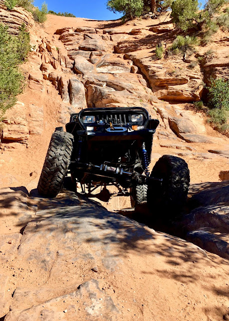
Rusty Nail is a hardcore difficult trail.  The trail begins at a left hand turn off the end of Gold Bar Rim.  It heads south then circles east.  It ends where it connects to Golden Spike and exits the entire length of Gold Bar.  The actual trail is only 1.9 miles.  The entire length of the route is 7.8 miles.  There are three major obstacles on this short extreme trail...Riff Raff, The Wall, and for scary fun, No Left Turn.  We headed out with Dee and Warren to tackle the challenges of huge boulders, tall ledges, and narrow switchbacks with views of a canyon below.  It was another gorgeous day with  beautiful blue skies, plenty of sunshine and a cool breeze.

First up was Riff Raff.   Before starting her climb, Dee explained the correct line for tire placement and then we watched.  What you can't see in the picture is a deep hole to the left of the passenger tire.  It's a little tippy and slipping off into the hole might cause a flop.  


Up next is The Wall.  Straddling the crack between the two boulders at the bottom, turning driver and climbing the ledge were the directions.  Warren's climb is flawless. 
Last, we come face to face with No Left Turn.  Joe and I had no idea what to expect and it wasn't until we saw Dee's pictures that our mouths dropped.  The trail at this point is narrow.  Large boulders were on my side.  A bottomless, at least it seemed that way at the time, canyon was on Joe's side.  Its a good thing he keeps his eyes on Dee and the trail.  Dee spotted us down a huge...ummm, enormous...boulder with lots of other boulders all mixed in.  Very tippy!  I'll let Dee's photos tell the story.


Thanks Dee for a successful run on the most difficult trail we have done...so far !


It was a great day wheeling with Warren and Dee.  Warren waits while Joe and I watch Dee's line on Riff Raff.  


Our last sight of Warren before he drops off No Left Turn.  See how close he is to the edge?


It's always a treat to follow Dee. 


We could see Jeep Arch from our lunch stop...a zoomed in picture.


We watched the clouds on the horizon...  

...as they moved closer...  
If you look closely, you can see the Colorado River in the center of the photo.


...and then overhead.  So pretty !
Until next time, 
HAPPY TRAILS ! 

Saturday, May 27, 2017

Friends and Fun

Gopher Flats
Moab, UT
May, 2017

The middle and end of May was filled with lots of fun and visits from friends.  First, our friends from Belgium, Guy and Catherine came for a four day visit.  We actually met them here in Moab in 2013 on the primitive trail at Landscape Arch.  They returned for another visit in 2014 for more off-roading and hiking.  We heard from them this past spring and were excited to learn that another visit was in the works for May.  

Moab Friends For Wheeling had a spring highway clean-up planned for May 13.  As always, the fun for the day was Metal Masher Trail afterwards.  


Guy and Catherine met us at the Gemini Bridges parking lot on Hwy 191 for a fun day on the trail.  


The weather was perfect. Our day was full of laughs with lots of "WOW!" moments as both recalled how beautiful it is here. 


 The next day, the club run was Behind the rocks...another trail with spectacular views and action packed obstacles.  Guy and Catherine were up early and eager to hit the trail.
Behind the Rocks is one of the trails that has many intersections and one I don't think I could find our way on.  It seems every time we go, we go a different way.  Jeff was our leader this day and much to my delight he headed straight to the sand dunes..."Wahoo!".  
Looking back from further down the trail, we could see the dunes...center in the photo below.
BTRs is 12.6 miles with many large ledges no matter which direction you go.  Add another 10.5 miles for the exit route.  The first obstacle is The Gate Keeper...a great warm up for later.  There are obstacles named High Dive and White Knuckle that can cause roll-over.  High Dive has a bypass and White Knuckle (no bypass) has a winch point.  Jeff, driving his samurai buggy which he built himself, was the only vehicle to climb White Knuckle.  He went first and made it look so easy, but it was not meant to be for the rest of us.  We were next to last in line and decided before we began the climb to winch...our first time to ever use a winch.  Looking up at White Knuckle...


 Glen hooking up our winch...
Guy and Catherine's 4 days flew by.  It was great seeing them.  They pulled out on the 17th headed north.  

On Friday the 19th, friends Libby and Corky arrived in Moab.  Corky had just bought a jeep buggy in Havasu and came straight to Moab.  We met the two of them last October.  Corky was anxious to get his new toy on the trail.  The next day, Dee, Corky and Libby and Joe and I planned to do Hell's Revenge.  Ummm, just like us a few months earlier, it wasn't meant to be.

By the time we reached the parking lot, we heard a bad noise under the hood.  Turned out to be the cooling fan.  Joe and Corky spent the rest of the day making a repair.  


With repairs and wiring completed, Steel Bender was the choice for Sunday.  It is practically in our back yard...close to home just in case.  Clouds were dark all afternoon, but we only got a few drops of rain as we were heading out. 

Jeff and Susan led the way followed by Corky then us...


...and Dee brought up the rear.
 There are lots of play areas with steep ledges and off camber spots.  The main obstacle, The Wall, is about 5.2 miles into the trail going from south to north and our turning around point.

What you can not see in the photo is a deep undercut at the bottom of the ledge.  After a couple of tries to get lined up, Jeff goes up first...Wahoo!


...followed by Corky...(his first obstacle in his new jeep buggy) 
...and followed by Dee. 
Because of some geometry issues and the fact that we are about 5 inches too tall, Joe chose the bypass.
 Of course, coming down the bypass was exciting.  Nothing like a wheel lift to get the blood flowing.

Wanting to stay close to home, the next choice of trails was Behind the Rocks.  One might think...again?...but it never looks the same as we never go the same way.  Dee led...we (Corky and Libby, Joe and I) followed !  I like this game of follow the leader !

It was a gorgeous day...mild temps, cool breeze, sunshine and blue skies.  The Gate Keeper once again greeted us.


The Rocks as the locals call them (or you might hear them referred to as The Terra Cotta Warriors) are a scenic highlight.    


 We all opted to bypass High Dive.  Here we are parked in the wash at the bottom of High Dive and are going to climb UpChuck.  UpChuck is a "lesser" obstacle.  Dee describes it "like the wedgy on Poison Spider, but on steroids".    


Dee's photo (thanks Dee) of us climbing UpChuck with High Dive in the background.


 Our time with Corky and Libby went by way too fast.  Plans have been made for a longer visit this fall.  Cant wait !

Looking back on The Rocks.
Until next time...
(Dee's photo) 


 HAPPY TRAILS ! 

Monday, May 15, 2017

Lockhart Basin

Gopher Flats
Moab, UT
May 6, 2017

Lockhart Basin has been on our to-do list for a couple of years.  The total distance is around 110 miles which includes 36 miles of 4X4 trail and around 65 miles to get to the trailhead.  That makes for a 10 hour day IF all goes well...way too long to leave our pups.  A huge thanks to our good friend and neighbor Susan who agreed to come let the pups out for a stretch and potty break mid afternoon.  This made it possible for us to join in on the club ride.  Joining in the ride were Dee, Warren, Larry, Carole, Joe and Ginny, Bronson (from Blanding) and his dad Tom, and us.  

We did the trail from south to north.
The meeting place was Newspaper Rock...my first time to see this amazing State Historical Monument. 


Heading west on Hwy 211 under a canopy of green gave way to dramatic scenery.

 We made our second stop close to Hamburger Hill Campground to meet Carole and Joe and Ginny who had camped the night before.  We all aired down and topped off the gas.  


L to R: Joe and Ginny, Dee, us, Bronson and Tom, Carole, Larry and Warren

Shortly after, we crossed Indian Creek and stopped to check out the falls.

It was a rather overcast day with dark gray clouds and the sun popping out from time to time.  We managed to park for lunch and just as everyone was beginning to eat, a rain squall moved in causing us to all scramble back into our vehicles to eat.  The sound of thunder and bolts of lightening we saw several times during the day were spectacular.  Luckily the heaviest rains and windy conditions held off until we reached Kane Creek Road heading into Moab.  It was not a pretty site.  I felt so bad for the hundreds of tent campers we saw.  Their tents and bedding reminded me of colorful blimps or balloons soaring through the air. 

The Moenkopi rock formations along this trail are beautiful with all the striations.  These red sandstone formations are millions of years old...so hard to grasp that many years, yet so easy to appreciate their beauty.


 Eventually we began to climb.
Dee leads followed by Carole, Joe and Ginny, and Bronson and Tom
We traveled several miles from the south side of Mitten Butte to the north side.


 Rain squalls were ahead.

As we rode along the mesa, Warren pointed out several points of interest.

The first formation in the center going left to right is Washer Women seen through Mesa Arch in Canyonlands. 


The first time to see the Colorado River on this trail.
 And can you find the Pig and her Piglets rock formation?  Sleeping Buffalo is also in this photo.  Both are formations we look for on many other trails including Poison Spider.
Pig rock is the light colored rock on the left and Buffalo rock is the light colored rock on the right.  I zoomed in as much as I could, and we could just barely see them from the trail.


From there we head down towards a narrow canyon and back to familiar territory to a 3-way intersection for Lockhart Basin, Chicken Corners and Hurrah pass.  This section is about 2 miles and the most difficult part of the trail.


 From here I have no more pictures.  Once we were headed towards Hurrah Pass, the winds were vicious and the rains were torrential.  It literally rained mud !  Thank goodness we were in Pearl.  Not a great way to end the day.  Mother Nature certainly added some excitement and chatter on the CBs.  

This is a well maintained and beautiful trail, but beware the rocks have eyes.  
 What a great group of friends to wheel with ! Until next time, 


  HAPPY TRAILS !